The Trifecta

Pinnacle, Shoestring and The Throat in a day

By Alan Cattabriga


The Details:

1. Pinnacle: Leave Car 6am,  Back down 9:15am.  (3hrs. 15min.)

2. Shoestring: Leave car 10:20am,  Back down 12:10 (1hr.50min.)

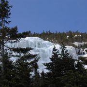
3. The Throat: Leave car 1pm, Back down 5:50pm. (5hrs.50min.)

Total Time: 10 hrs. 55 min.

Total Distance: 16.07 Miles

Total Elevation Gain: 7613 ft

The Story….The Adirondack climbers had the cool name, “The Trilogy”, damn it!! I grew up reading Tolkien,  my other main staple in my youth was Castaneda,  a load of killer titles, but the “collection” of books had no name. Good thing they did not, for I don’t think I could ever climb as many alpine routes in a day as Carlos has books. But “Trifecta”, now there is a sweet sounding word. A word that can be applied to a few different activities…..Of testing the legs and getting some times;In Jan ’08, Ted Hammond & I did a Shoestring/Lincoln’s Throat combo. It took us like 11hrs; Shoestring went like clock work but the approach to the Throat was hideous, with deep snow and the stream open here & there. In one of the “here” portions I took a little dip. We also lost some time for we wanted to do a unknown left finish to the Franconia Ridge that leaves the main drainage before the Throat, but we took our turn too soon (my fault) and after a long, cool gully, it dead ended at a spruce wall that resembled the Spartan spears in the movie 300. We descended the gully (I was really pissed at my faux pas) and motored up to the Mullet (right slab) line to Lincoln’s summit and enjoyed an awesome sunset. Our mistake took time but gave us a huge sunset gift.
This past Dec. I dabbled again, this time with Damnation, descending Lion’s Head then Shoestring combo. I kept my pace at a slow boil in the ravine, but being alone I went hard on Shoestring and took 20mins. of my fastest time there. (6.5 hrs. total time.)The ice season comes full circle every year, we start & end in the alpine zone, time to stop thinking and start doing. The second wk. of March had started, conditions in the zone were looking good. The next few days were going to be sunny and nights cold. My day was going to be Friday the 13th. Worry? Why should I? I’m not superstitious, though the last time I took this date off, I augured into the ground off of Omega’s first pitch and got totally owned.Of the Trifecta: Pinnacle Gully, Shoestring Gully & Lincoln’s Throat;I’m up early Fri. morning and leave the house at 3:45am. I’ve gone over the times I want to do each section and the best way to do this. For the ravine portion, the fastest way would be Pinnacle then down South. I leave the car in Pinkham at 6am. The moon was just starting to wan and low, but lit the trail nicely.
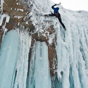
I get to the ravine just as the sun is lighting up the headwall, it’s cold, single digits and a bit windy but bluebird. I hear the sound of a snowmobile coming and talk with avy ranger, Justin, as I get ready. The snow in the Fan is glazed and rock hard, Pinnacle looks beautiful. The ice was hard and brittle, with thin cracks/lines running this way and that. Because of these cracks my tools were breaking off triangular chunks which made tool placements kind of a pain. After the first 200′ the rest of the climb is hard, ice covered snow. Total fun, single tool climbing. I’m down South Gully fast, remove the ‘poon’s and jog the trail down.I find the snow absolutely perfect on the approach to Shoestring. So hard, I put the crampons on as soon as I started going up in the woods. The gully was in great condition and the direct finish awesome. The Webster Cliff Trail was very hard snow and crampons would have been the ticket, but I wanted to jog down so I took them off. After the first steep sections, and a few borderline out of control glissades, the rest of the trail was nice. It was now 11:50 and I wanted to start the approach to the Throat by 1 to stay on time. Perfect..
Now I thought the driving parts would be great, time to refuel, crank some Dead, take the boots off, give the feet a break and it was…. but when I got out at Lincoln’s parking, my legs had stiffened up pretty bad. It took a fair amount of hiking to loosen them again. Even though the snow conditions had been great, I decided to bring the snowshoes, I did not want to get into the Lincoln’s approach drainage and have a posthole party.
The Old Bridle Path was good & packed, I put the shoes on for the steep bushwhack down to the Throat’s drainage. Once there I discovered a gift – two people had gone up earlier and broken the hard crust. I removed the shoes and followed their tracks. The going was good and eventually the snow hard enough to stay on top. The Throat was fat and I climbed it right of the usual ice hose, the snow above the ice was excellent. On Lincoln’s summit there was a light wind and I could see for miles. I’m stoked!! While digging the viewsAl I drink a Red Bull and eat the last of a cookie & Balance bar. It’s 4pm and time to go, the Franconia Ridge to Little Haystack was all ice and hard snow, very nice. The hike down the Falling Waters Trail was packed, hard snow so I keep the ‘poons on almost the whole way down. I got back to the car just shy of 12hrs. (10hrs of total hiking/climbing) after starting in Pinkham… A phone call home and the next stop is the nearest beer store.There are many link-ups one can do around here. Adding Adams Slide on Cannon to what I did would be very doable. For this linky I thought of the car as a base camp and I could keep my pack light, once above tree line I had on all I brought for cloths, a little food and 1 pint of Gatorade per section, except on the Throat, I had only about 8oz. left and the Bull.
Come to find out The “Trilogy” got sent about the same time as my day by Joe Szot & and a friend. Awesome! Then Emilie Drinkwater repeats it a few days later, solo. Yeah, totally awesome.. To be out there, a long day, alone takes some fortitude, but the feeling you get……Now I’m in no way am thinking that I’m the first person to do this link-up. I’ve never heard of it being done though, it was a test just for me.AlanMore Links ……..Lincoln’s Throat – Mt. Lincoln – eguide on NEicePinnacle Gully – eguide on NEiceThe Throat– Photo search on NEicePinnacle– Photo search on NEiceShoestring – Photo search on NEicePhotos & content by Alan Cattabriga, maps, links and web page by Doug Millen

Mt. Ruapehu

North Island, New Zealand

MtRuapehuNZ

Graham Johnson climbing Ice on Mt. Ruapehu.

Photo by: F. Stephens

Silent Spring

The Bethel Crag

by Josh Hurst / Photos by Eric Eisele and Ian Austin
Josh on Slient Spring

Josh on Silent Spring

Finally got the job done!  Super psyched! We called it Silent Spring, M12

The real praise goes to Ian who was a patient driver and belayer for the 4 days of redpoint attempts and 3 days needed to equip the route.  He never bitched once about the 3-mile approach, would never let me break trail and was always full of encouragement.

Training all fall and winter paid off- just in time!  Silent Spring feels harder than the current routes in the Cathedral Cave and is way more powerful.  It’s a combination of precise, technical feet and super burly power.  I was tearing muscle every time I tried it and could only take 2 tries per day before being totally wiped-out.  I would then hurt for the next 2 days.  A week after sending it my obliques and lats still hurt.  I’ve learned that you don’t just train for strength, but mentally for the pain associated with a pitch like this.  The route is 110′ long and overhangs 45′.  It’s 14 bolts, 1 cam and a screw.  The ice was getting beaten by the sun so I dropped a rope with a draw on it to protect the ice.Josh on Silent Spring

Silent Spring starts on a thin slab to a stance where you look out horizontally past 8 draws hanging above the valley.  You torque out a flake system to the lip, the crux, where your feet lead above you.  Once around the lip it’s M8 to the hanger, characterized by big moves on an overhanging wall.  My first go the day I sent I got the crux move for the first time and then dropped my tool- it took a 250′ fall into the trees.  Ian rapped down to get it while I took a rest.  Ice was crashing down around us and I knew that this was the last burn of the season ssJosh03no matter what.  When Ian returned, tool in hand, I turned it on and got the job done!  The funny thing was one of my front points was really loose so I couldn’t get the needed heel toe rest after the crux so was left to improvise the M8 moves, then ‘rested’ my way up the final 30′ of M7 to the top.  Usually, the ice is the easy part but even it overhung 2′!  The whole time I was thinking about Jim Ewing’s advise on how to get up hard routes- ‘JUST DON’T LET GO!’  YeeHaa!!!

Josh

Madison Gulf

The Presidential Range, NH

Of the UP! & Ova…….. aka; Holy F*%*!

by Alan Cattabriga

Madison Gulf from the approch

Madison Gulf from the approach

After leaving a car at the Appalachia parking in Randolph, Tim, Ted, Doug and I are on the Great Gulf Trail in Pinkham Notch by 7am. The plan is to hike into Madison Gulf, climb the route, “Point”, then continuing up to Adams summit and down the other side via the Airline Trail to Appalachia.

Temps are in the upper 30’s but the trail is packed and hard. We decide to leave the snowshoes at the car. ( big mistake ) We figured the only place we would need them would be for the bushwhack from the Madison Gulf Trail to the ice. The approach is packed & the descent would be for sure.

The day is bluebird. The trail nice but all too soon, about halfway in, the sweet trail conditions go south fast. Once on the Madison Gulf Trail it was no longer packed. There were savage spruce traps, very little good footing and to add more to it, we kept losing the trail. The snow is so deep you are up higher in the tree branches, where trails are not trails. Blazes were non-existent.

Our good pace went to a crawl. In some places, literally. Hours slipped by as we lost the trail, again & again. Back-tracking every time to where we knew we were on it and trying again. At last we were in line with the ice and could see it good… we made the straight plunge. 7hrs. had passed since our departure at the Great Gulf trail-head to the base of the routes. Holy crap…

Madison Gulf MapAt the ice wall the sun is warm, the ice is huge and beautiful. My feet are soaked. Sitting on a rock, I wring out the socks and let my boots air out for a bit. Next we have 300’+ of ice, another bushwhack to the Buttress Trail then up the open summit of Adams. The ice is pure fun, the bushwhack above, because of the deep, hard-ish snow, is quite easy.
At the Buttress Trail we split up, I head up awesome snow to Adams and the others for the Star Lake Trail & Madison Hut.

The Airline Trail from Adams summit is in excellent shape, and it’s “knife edge” section bare rock & alpine plants. I lounge here for awhile wondering if I’m ahead of the gang. I decide ( mainly due to soaking wet feet) to book it down.

11hrs. 50mins after leaving, we are all down…. what a day! I’d go back in a heartbeat too.


Photos by Alan Cattabriga, & Doug Millen.


The Trilogy, Adirondacks NY

The North Face of Gothics, Grand Central on Marcy and Colden’s Trap Dike in a day.

by Emilie Drinkwater

Emilie

My decision to try the “Trilogy” was made on a Sunday afternoon, March 15th. Inspired by recent link-up activity in the Northeast (Alan Cattabriga’s Trifecta in NH and Joe Szot’s Adirondack Trilogy), I decided that conditions wouldn’t get any better for my own attempt at the Trilogy. This link-up starts on the North Face of Gothics and continues up and over Saddleback, Basin, and the shoulder of Little Haystack, dropping into Panther Gorge, ascending a line called Grand Central to the summit of Marcy, down Marcy, into Avalanche Lake, up Colden’s Trap Dike, down the backside and out.

I started this adventure at 4:30am on Monday morning (March 16th) with a two-mile uphill bike ride from Keene Valley to the Garden trailhead (having dropped my car at the Adirondack Loj the night before, I didn’t want to ask anyone to drive me anywhere at 4am). I started the actual Trilogy at 5:02am and was determined to ski as much as possible, as I had opted not to bring snowshoes and hate walking in crampons. The first mile and a half was slow going and I probably took my skis on and off fifteen times to cross large patches of bare ground or ice. Eventually the snow became more consistent and I was able to move quickly, reaching the base of the North Face at first light.

Choosing a line to the far right on the North Face allowed a straightforward ascent to the summit, which I reached at 8:30am. Little did I know, the difficult part of the day was only just beginning; having never been on this section of the Range Trail, I was under the impression that I would be following a ridgeline all the way to Little Haystack. Wrong! In fact, this section of trail descends and ascends each of those peaks and includes a section of steep, open rock that seemed to be in the range of 3rd or 4th class climbing (at least in ski boots and crampons). In addition to now feeling very sluggish in the legs, this down-climb had slowed the pace significantly.
I continued plodding toward Little Haystack, skiing sections on occasion, but mostly walking (skis on my back) on packed trail, all while snagging the skis on every overhead branch and limb, wasting energy climbing over and under downed trees. At last I started to get views of Marcy’s impressive south face and the remote Panther Gorge below. Having never been on this section of trail, let alone anywhere near Panther Gorge, I knew my only hope of getting in there would be following the tracks of Joe and his partner, four days prior. Sure enough, just past the Slant Rock/Marcy Trail intersection, I spotted a faint set of tracks heading into the Gorge. I nervously followed the tracks (these guys had wisely put snowshoes on for this section) down into the abyss of Panther Gorge. Almost immediately, I lost their trail and started desperately postholing. Panicked and exhausted by dropping into waist deep spruce holes (for more than 45 minutes at this point), I started to regret bringing skis instead of snowshoes. The skis caught on everything and what branches they didn’t break, they instead shook thousands of pine needles down my back. I knew turning around and postholing out would be more difficult than what I’d just come through, so I made the conscious decision to continue, hoping to make it to some feature that would take me up and out to the relatively open slopes of Marcy’s south face. Only minutes later, I regained Joe’s tracks (and the greatest sense of relief ever!), and followed them up a short, steep step into the Grand Central gully. The sunny, openness of this snow gully was fantastic, but my legs were now so tired that I was reduced to taking 50 steps followed by 30-second rests. I had also long since run out of water and had been forced to fill a water bottle from a dripping icicle; I did treat the water but probably not for long enough… hopefully I won’t have giardia next week!

I reached the summit of Mt. Marcy at about 3:30pm. Sadly, somewhere in my Panther Gorge struggle, my watch had set itself back an entire hour, leading me to believe it was 2:30pm at the summit. Suspicious of the sun’s location in the sky, I checked my cell phone and discovered the mistake. Feeling pressured for time, I put my skis on and immediately started my descent on the Marcy ski trail. It should be noted that Joe’s descent from the summit of Marcy took the Feldspar/Lake Tear trail down to Lake Colden, whereas my descent (because I chose to ski) took me down to Marcy Dam (a mere two miles from my car), in approximately 35 minutes. From here I headed back up into Avalanche Lake and, for the first time in the day, felt so happy to have skis, which were faster and allowed my legs some recovery time.


I reached the base of the Trap Dike at about 5:15pm and because of its western aspect, the sun beating down was warm and bright as if it were noon. I took a quick break here to eat some sugar-laden, caffeine-laced snacks, and I started back uphill again with a second wind. Tired of listening to my heart race, I pulled out the ipod to get through the last tedious section of the Trilogy, and was spurred along by such motivational classics as Eye of the Tiger and The Final Countdown. Despite this, my legs were so tired that I had been further reduced to 10 steps followed by 30-second rests.

I reached Mt. Colden’s summit at about 7:15pm, just as the sun was setting. Fear of missing the Lake Arnold trail off Colden’s summit in the dark, made me move quickly and I reached Lake Arnold before I needed my headlamp. From this point, I was able to ski the snowshoe trench out to Marcy Dam and from the Dam to the Loj, reaching the parking lot at 8:44pm.
15 hours, 42 minutes, my final time (unless I’ve done the math wrong, which wouldn’t be surprising). I went into this with low expectations, never trying to be faster than Joe, only hoping to finish at all. I like to remind myself that this Trilogy was never my vision only something that seemed like a good challenge. I believe that conditions couldn’t have been better and having a track to follow was indispensable. While I may not be at my fittest, an extensive endurance background did finally pay off. And, when Jan Wellford recovers from a broken pelvis, you can bet that my time will be crushed as well!

–Emilie Drinkwater, 3/19/09

Emilie is owner/guide; Cloudsplitter Mountain Guides in Keene Valley NY. www.cloudsplitterguides.com

Crushing it in the "Can Rocks"

by Robert Ginieczki

There are few words that can describe the Canadian Rockies, especially along the Icefields Parkway corridor between Banff and Jasper. I guess the word ‘core’ and ‘dramatic’ are about all that come to mind for now, at least in the English language. So this story goes, my buddy, Stanislav, and I make some plans to head north to get on some ice, ice that’s bigger than the 2 full pitch laps we’ve been running on routes like Bridalveil and Ames here in Colorado. It was time for my bitchin’ to stop and buck up for a trip to the looming limestone walls of Canada.

Link to Story (PDF)

Photos from the Trip

Source: Robert Ginieczki www.grizguides.com

Adirondack Mountain Guides Nepal 2009 Trip Report

By Ian OsteyeeSherpa_Bridge
Porters crossing a foot bridge enroute to Namche.

On this season’s trip to Nepal we traveled through London, Delhi, and then on to Kathmandu.
Our goal – to climb the 700-meter water-ice climb, “Losar “,  WI5, VI, in the Khumbu region of Nepal.

Our travel left the ordinary flow immediately as a 62- year old passenger had a heart attack between Newark and London, leaving myself and a former British Army medic as the two most qualified personnel on board. We managed to stabilize the unlucky fellow and turned him over to paramedics in Heathrow. Then, to add a bit more to the trip’s flavor, somewhere between London, Delhi, and Kathmandu half of our bags were lost.
Despite the bumps in the road, we arrived in Kathmandu happily met by Kami Tenzing, a Sherpa friend of mine. Kami is the man who made it possible for the blind Erik Weihenmayer to reach the summit of Everest. I met Kami while guiding Erik in the Khumbu previously, and Kami spent a few weeks visiting me in Keene this past summer. Kami is one of three Nepalese to have met the president of the U.S. – the King, the Prime minister, and Kami. Kami organized everything on the ground for us, and always had the answers, even to lost bags.
After celebrating the New Year in the ancient city, we flew up to the Khumbu and walked for two days up to Namche Bazar while acclimating to the thinner air at 3800 meters. The Khumbu region’s most famous ice route, “Losar”, was on our list of goals for the trip. Having done it the season prior, I was looking forward to climbing it yet again with the four other climbers in the Adirondack Mountain Guides Nepal party. As we came up the steep slope toward Namche, our first view of “Losar” revealed a thin, but continuous line of unknown quality. The following day’s approach to the base unfortunately revealed a waterfall not yet frozen, but trying. “Losar” was not in, but undeterred, this freed us up to start looking at other first ascent projects that I had scoped out the year before. Fortunately, our bags caught up to us in Namche thanks to the ultra-speedy Dzo-cow express and Kami‘s expedition magic. A Dzo-cow (“dzo-kyo“) is the hairy beast that you get when you cross a male yak with a cow. Things were gaining momentum as we took in the views of stunning peaks like Ama Dablam.

Zokio_express

Loading up the Dzo-cow (“dzo-kyo“)

Moe Corrigan, Chonba Sherpa and I spent a day probing around in the forest on Kwongde, the same mountain “Losar” is located on. Right of Losar flows an obvious line that drops almost 2000 feet into the valley. The terrain leading up to it was steep and covered in bamboo. We worked our way upward through it, eventually finding a decent approach and a reasonable camp site. Tents were pitched and dinner served. A cold night followed in the forest on Kwongde, letting us get a good start as Tom Drake, Steve Smith and I headed up the long approach looking for the world-class ice ribbon we had seen. After a short scramble up through a rock slot and several hundred meters of “Bamboo 5” we found a boulder-filled, rock-walled drainage leading to the ice. It was incredible to come out of the slot and find the steep, long flow towering above. It looked dry and sublimated, but inviting. Excited, I starting up the line, testing each swing, It was hollow in many places. Traversing back and forth, trying to find the well-attached line, I gained ground. The arid nature of the environment made the ice very dry and brittle. I was thankful to have the Camp Awax tools in hand, the thin picks which make quick work of that type of nasty ice. The pitch seemed to go on and on and never let up. I was running out of shortie screws and hadn’t found enough ice for anything longer. From below I heard Tom yell, “ten feet”. Thankfully, with my 70m Bluewaters run all the way out, I looked up and there was a bulge that luckily took 16cm screws and it was “off belay!”. Starting off the day with a full 70 meters of 85 and 90 degree ice, often not thick enough for shorties, had us all feeling a little on edge. Nothing to do about it but continue upward. A glance up showed the second pitch was to be more of the same but easing off higher up on the route. Another 70 Meters of thin ice dancing and tentative stubby placements led us up as the angle eased and the climbing became less demanding. We laughed as remaining pitches cruised ever upward never getting harder than WI 3+. Pure joy in the climbing, gaining altitude up the massive mountainside. Success!

Shaugdro_2_web

View of “Shaugdro”, WI5R, at center, with Losar, WI5, at left, viewed from near Namche Bazaar, Nepal.

Steve_Tom_Shaugdro

Tom and Steve follow the steep lower pitches during the probable first ascent of “Shaugdro” WI 5R, 500m. Osteyee photo.

That evening back at the teahouse, Kami Tenzing assured us that the route had never been climbed. Just the same, we’ll call it a possible first ascent, and for the sake of a name, call it – “Shaugdro” WI 5R, 500m, ACB (As Climbed by) Ian Osteyee, Tom Drake, and Steve Smith.

While we were across the valley on “Shaugdro”, Mark Arrow and Moe Corrigan had already headed up to Lhabarma and were climbing in Phulebuk. Phulebuk is a great feature just out of the way from the main trail system. It is full of 400+ foot ice climbs that are all at about 15,000 feet, and until the last couple of years have gone unclimbed. We joined the duo the following day, and I enjoyed watching from a comfortable grassy spot as the two different teams went to work on their respective new routes. Mark Arrow and Moe Corrigan excitedly returned to the meadow after soaked up the bright warmth during the first ascent of “Desconnor”, WI 4, 150m, a steep flow that invites basking in the sun. A kilometer south, on their chosen flow, Tom Drake and Steve Smith worked their way up “In Sickness and in Health”, WI 3+, 150m, a more shaded route starting with a beautiful column, then cruised upward on stunning ice amid surrounding peaks like Thamserku 6608m and Kangtega 6685m. Up the valley stands Cho Oyu and across the valley are Arakam 6423, Cholatse 6335, and Taboche 6367. These ice routes are solidly placed in one of the world’s most beautiful places to climb. Tom, Steve, Mark, and Moe couldn’t have been more excited.

Tom_In_sickness

Tom Drake works his way up “In Sickness and in Health”, WI 3+, 150m. Photo by Steve Smith.

Desconnor

“Desconnor”, WI 4, 150m.

The following day Tom Drake and Steve Smith headed up to Goyko Ri (5360m), and Moe Corrigan, Mark Arrow, and I headed back down to Namche hoping to find “Losar” in better shape. Unfortunately, “Losar” was still a waterfall. Out of time for other big approaches, we went out scouting for future trips. While on our scouting trip, we did find one small route that we had time to do near the village of Thesho. It was an hour walk from Namche, but worth the trek to get one last new climb in. Located over yak pastures and small, stone dwellings, this small route,“Bolognesse” WI 4- , 30M, was a great way to finish the trip. It was named for the meal that sustained us on the journey more than any other; yak meat, watery tomato sauce, and noodles.

Bolognesse

Osteyee leading up the small route,“Bolognesse” WI 4- , 30M. Somewhat reminiscent of a route in the Catskills or Pennsylvania but with a decidedly more mountainous view from the route.

Our trip was full of adventure – climbing and otherwise, but it was not over. Leaving Namche and back in Kathmandu, we discovered that Indian Air had cancelled our next days flight out of Nepal. Gathering our gear, we headed to the airport to see what we could figure out. Four hours of hustling, through crowds of the Hindu faithful there for a very special festival, along with some fancy talking got us on a flight that afternoon. Then another boring twenty hours of waiting in the Delhi airport when an excited airline employee hurriedly scrambled us to a different gate for our flight which still barely allowed for the baggage to be transferred to our Virgin Atlantic flight to Heathrow. Thankfully, without further delays we arrived back home, everyone satisfied and full of stories to share with friends for years to come.

Special thanks to Blue Water Ropes and Camp. The Blue Water Excellence ropes stayed dry and manageable through repeated uses in wet places, without any time to dry. The Camp Awax tools and Vector crampons performed flawlessly on some of the most dry, brittle and difficult ice conditions.

– Ian

Editors note:  Ian Osteyee is owner of Adirondack Mountain Guides in Keene, N.Y., and AMGA-certified guide with over 25  Years experience.  In 2008, Osteyee guided famed blind climber and Everest summitter Erik Weihenmayer and Rob Raker up the huge ice route, “Losar”,WI5, VI, 700M, in Nepal.

Ouray Ice Festival 2009

The Ouray Ice Festival was begun in January of 1996 by ice climbing pioneer Jeff Lowe In 2001.  Held this season January 9 – 11, 2009, the event features a gathering of international ice climbers, gear manufacturing exhibitors, and vacationing visitors excited by the chance to watch the scene from cliff-side platforms and trails.

Mammut

Ouray Ice Fest Blog  by Alden pellett

Batchawana Bay-Agawa Canyon

Ontario, CA

Ice Climbing North of Sault Ste. Marie Ontario in the Batchawana Bay-Agawa Canyon Area

by Shaun Parent

Located between half an hour and 1.5 hours north of Sault Ste. Marie adjacent to highway 17 this area hosts over 10 separate ice climbing areas.

In the area just south of Lake Superior Park in the vicinity of Montreal River Harbour are several easily accessible Ice climbing sites. Tower Road hosts over 30 short but steep ice climbs up to 10 meters in height. The road is plowed all winter so one can park a vehicle within 20 meters of the climbs.

Just a few minutes north short hikes of 15 minutes from highway 17 take climbers to the Panama Wall where there are 6 climbs up to 25 meters in height the most interesting of these is Aurora Borealis grade 4, 20 meters. Across the highway is the Ryall Wall, on which is found the spectacular “Mother of Pearl” a grade 3+ ice climb 20 meters in height.

For the more adventurous one can snowshoe or ski along Ranwick Road for 4 kilometers to Ranwick Rock, the site of summer rock climbing activities and a rock climbing guidebook. In the winter there are 8 ice climbs up to 100 meters in length. The access point for Ranwick is at the top of the Montreal River hill.

One area, which has received considerable attention in the past and should see complete development this season, is Cerro-De-Hielo (Mountain of Ice). Located 8 kilometers off highway 17 on the Carp River road at Batchawana. This area contains several individual climbing areas including the Transverse Mercator wall hosting THRESHOLD OF AQUAINTANCE Gr.4, 25 M. The Wall of Deception contains two excellent climbs JACOB’S LADDER Gr.4+, 30 M, and VERTIGO VENTANA a series of blue pillars and curtains rated Gr.4, 30 M high. The Wall of Sinn and the Wall of Sorrow shows promise for a minimum of 25 climbs of 20 meters in height and all in the Gr.4 to 5 ranges. The access road is supposed to be open all winter 2005 as logging is taking place in this area.

The Climbs of Mile 38 Road near the well know Chippewa Falls on highway 17 offers many enticing climbs. Located 4 kilometers down this plowed road from highway 17 the climb “BLUE AVENJURE” 100 M, Gr.3, saw 5 ascents by different parties within the first three days of its first ascent in 2002. It is one of the highest and most accessible ice climbs in the east shore of Lake Superior. The climb DUTCH TREAT Gr.4+, 50 M lies less then 150 meters from where vehicles are parked on Mile 38 road and gives two variations of climbing, one in a chimney choked with ice or a direct headwall.

Since the release of the AGAWA CANYON ICE CLIMBING MAP in 1999 and

“Superior Ice” guidebook in 2001 by Granite publishing many more climbers have taken an interest in this well known canyon located north of Sault Ste. Marie. Agawa Canyon has 54 climbs up to 200 meters in length along the 6 miles of canyon between mile 110 and 116. Climbers can enjoy the Algoma Central Railway passenger train service that will drop passengers off to enjoy winter camping at Mile 112 in the center of it all.

Ice climbers have during the winter of 2004 found access points to Agawa Canyon by snowmobile from the Frater Road. This access trail takes one to the edge of Agawa Canyon at Mile 110. Two new areas have been developed in this area, the “ONLY 17 WALL” and the “LIL-AGAWA CANYON” adds another 15 ice climbs to the area with routes up to 50 meters in length. The 2nd edition of the Agawa Canyon Ice climbing guidebook will be available in early 2005, and will include these new areas.

The second area mentioned in the “Superior Ice” guide, Montreal River (South Bay) at Mile 92 on the Algoma Central Railway has 10 climbs up 130 meters in length along a 1.2-kilometer wall of pristine granite. The favorite climb in this area is Comfortably Numb Gr.3+, 120 meters at Mile 92 (South Bay). One can access this are either by train or by snow machine.

A Reconnaissance expedition by snowmobile in January of 2004 up the Montreal River uncovered the SPK, Majestic and Mystic Walls. This face of granite is in excess of 4 kilometers long, and hosts what appears to be the Mid-Continents highest and most aesthetic ice climbs. The highest ice climb in the Mid-continent “STRATOSPHERE Gr.4, 260 meters is found here. Along the same face is the route RITE OF PASSAGE Gr. 4, 160 meters in length is an ice filled fault line. The TURQUISE COYOTE Gr.4, 70 meters and its upper section the EMERALD BOBCAT Gr.4, 50 Meters contain the largest mass of ice in the region. The main danger of accessing these climbs is the Montreal River Reservoir, which seldom freezes, and offers many large expanses of slush and open water throughout the winter months. Several snowmobiles were abandoned last winter in the slush, and one snowmobile went through the ice in the winter of 2003, but was rescued 10 minute later, loosing the machine.

This area is quickly gaining the reputation as a climbing destination for ice climbers in the Midwest and throughout North America, the height and aesthetic value of the climbs.

The local guidebook “Ice Climbs of The Batchawana-Montreal River Harbor areas is now in it’s fourth edition. It includes the climbs of the Montreal River Harbor Area, Cerro-De-Hielo and Mile 38 road. A fifth edition is due out in February 2005, and will contain over 100 ice climbs in 14 separate areas.

Photos, ice conditions, route information is posted frequently on www.climbingcentral.com in Rumor Central.

For ice climbing instruction, guiding, specific route beta, climbing guidebooks, gear rental and snowmobile shuttle service. Contact the North of Superior Climbing Company www.northofsuperiorclimbing.com info@northofsuperiorclimbing.com 705-946-6054

Damsel In Distress

Doug Madara on “Damsel In Distress” Mount Willard (Upper East Face), Crawford Notch NH

by Karen Paine/ Doug Millen